Wednesday, July 27, 2011

Honestly, we really did have a snow storm that cancelled my flight.

Honest, we did.  Yesterday the roads were horrible to drive on -- although not as bad as the side walks for walking. Today was absolutely lovely and ended up about 12 or 13 degrees with warm winds of a Nor' Wester.  After lunch Sue and I drove out to Sumner to walk on the beach and enjoy the sun and the warm wind.  A bit less wind and the jackets would have been off.  The first thing on my right ans we climbed down to the Sumner beach was an example of the flowering bush that lines this part of the beach.
I have hunted allthough the internet looking for its name and can't find it.  It looks to be part of the Hebe family, but it appears to be much bigger than in most of the pictures on the net.  It certainly didn't seem to be particularly bothered by the snow, rain, hail and sleet that had fallen only a couple of days before.
the cliff above shows the extent of some of the earthquake damage.  I imagine that most of the houses above are now part of the red zone and slated for demolition. This time last year it was highly desirable Real Estate with an amazing view of the South Pacific.  At the bottom of the picture are the double stacked Sea Crates at the base of the cliff to offer some protection to the traffic from tumbling rubble.


Shag Rock used to be a 8m rock formation at the entrance to the Christchurch estuary. During the February earthquake it collapsed to nearly half its original height. Locals initially renamed it Shagged Rock, but popular opinion seems to have settled on Shag Pile as its new name. Sue and I came up with Shag Rubble.
I imagine that it was named for the New Zealand Cormorant, the Shag.  Apparently there is a breeding colony (known as shaggerie) nearby of these now- protected birds.


Finally we stopped Afghan cookies (from the Darfield Bakery) and tea.  We were parched and starved having had Vietnamese Food a scant three hours previous.  It was most necessary to eat in order to keep up our strengh for dinner.  Sue took a great deal of time to set up the perfect shot of the two of us on the last outing of this trip (Air New Zealand willing).  I, who wanted to get back to the bench while the tea was still hot, had a cheerful New Zealand lady take our picture.

Tuesday, July 26, 2011

Iwannagethomefromnewzealand


 I have never before experienced a flight being cancelled, especially due to 5 inches of wet snow, but NZ has been full of surprises this trip. It is the heaviest snow fall in 15 years and the coldest temperature since 1918. Cantabrians enjoyed it immensely and as one wag said, "it is the icing on the quakes."  My friend Sue took these pictures.  The one on the right is our street, to the left of the picture, my little car.  
There had been a going away party at the house for me on Sunday afternoon, with way too much good food, put on by Rick and Lynn. There hadn't been much snow as yet, although Sue and Phil reported a lot of cars in the ditch en route to Darfield.  Nest morning we woke up to about 4 inches of snow, which increased over the day.  This is very unusual for Christchurch because so many storms come from the west, and most of the snow has been dropped in the mountains before it gets down to the lower altitudes.  Christchurch frequently get some fluffy snow overnight which melts in the morning sun.  This snow came from the Artic (oops, busted-Antarctic) on a south east wind.  The dogs, above left, were both born in New Zealand had never experienced snow.  The little one Wilma aka Boo Boo, wore herself out playing in the wonderful stuff.  About 1:00pm, we found that my plane had been cancelled, and Lynn and I started to work at getting the new one booked from Monday afternoon to Thursday.  Not a problem.
It is odd, I have really enjoyed being in Christchurch and am looking forward to coming back, but I had really planned on being home, enjoying some hot weather and eating tomatoes from the garden.  My mind already moved to "Ontario mode".  However, the weather is now sunny the temerature 12 degrees and I am going with Lynn and Rick to meet Sue and Phil at a Vietnamese restaurant near Church Corners where Phil is currently working.  Wheels up tomorrow at 3:10.

Saturday, July 16, 2011

West Coast of New Zealand

Earlier this month, I took a train from Darfield
through up to Arthur's Pass.  Sue dropped me off at the train station in the morning -- She took a picture of me with the holly bush growing there. The station is pretty much like the one in Wyoming, Ontario.  The building that was once the train station is long gone (if there ever was one) and a shelter takes it's place.  I booked my ticket to and from Greymouth by telephone and it cost 105.00 NZ return.  There was no difference in the cost if I had stayed on to Greymouth.  My ticket was given to me by the attendant when the train stopped at Darfiled.  She then grabbed my bag and threw it up into the baggage car.  The train is a lovely ride, just as at home.  Two seats face another two, with a table in between, and lots of leg room.  It is a very pretty ride up to Arthur's Pass, an entirely different view from the one we saw last Spring by car.  The Alps were snow covered, but no snow yet at Arthur's Pass that day.  Viv met me at the train station and we went down to the West Coast by highway.  The highway is two lane with an occassional passing lane and is, really, a good secondary road.  They get quite icy in the morning as there seems to be a mist that freezes on the pavement, a little scary, but a recommendation for driving the speed limit.  It was an interesting trip, I saw a lot of beautiful scenery as well as cows, fauna and flora. I also saw plenty ofexamples of what is called  "hump and hollow".
 
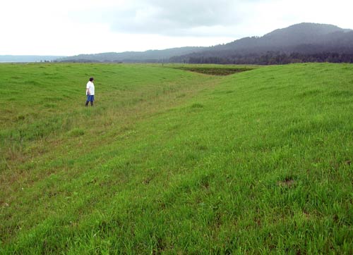
 Before sowing with pasture, the land may be contoured into a giant corrugated-iron pattern. This allows water to quickly drain away and prevents ‘pugging’ (heavy trampling of the soil and pasture) by grazing livestock.

This hump-and-hollow pasture is at Tetaho, South Westland.--the picture is from an agricultural website. 


 Beside is a picture of the monument itn Hokatika (where I stayed).  It is a monument to the New Zealand troops who fought in the Boer War, as well as to honour the coronation of Edward the VI. The town is on the coast itself, as is greymouth, and there are plenty of 'batches' that are rented out full time.  In the summer they have a nasty little critter called a 'sand fly' (namu in Māori). Sandflies, like mosquitoes and other flies, are members of the order Diptera, and belong to the family Simuliidae. Similar species found elsewhere are called blackflies.  The Greymouth area is cursed by the darn things; fortunately, I was there in their off season.  Consequently, I enjoyed the walk on the beach last night, but the Tasman Sea looked too cold to dip the toes into.  June 2nd was the first time in New Zealand that I have seen the sun set over the ocean.  It was the last time too, as the weather had changed by sunset the next day to rain.  Luckily, the next day, although overcast, was not rainy.


We headed off south the next morning.  First we stopped at a town called Ross which still has an open cast gold mine that has been operating since 1988.  Above is the mine on the ocean side of the road.  There is another large bit on the other side of the road.

Heading south we stopped to enjoy the view of Lake Ianthe.  Apparently the explorer who discovered the lake was somewhat of a classicist and felt that Ianthe was the appropriate name for this beautiful still lake.
 As you can see from the picture on the right, the area is definitly temperate rain forest.  I was there in the winter -- a good sweater is adequate in the sunny daytime and not bad for a dry evening.  By the time we got to our destination, however I had need of my jacket and scarf.


Speaking of destinations this was it on the right; the Fox Glacer.

Fed by four alpine glaciers, Fox Glacier falls 2,600m on its 13km journey from the Southern Alps down to the coast, with it having the distinction of being one of the few glaciers to end among lush rainforest only 300 metres above sea level. Although retreating throughout most of the last 100 years, it has been advancing since 1985. In 2006 the average rate of advance was about a metre a week. In January 2009, the terminal face of the glacier was still advancing and had vertical or overhanging faces which were continually collapsing.
The outflow of the glacier forms the Fox River. During the last ice age, its ice reached beyond the present coastline (taken from Wikipedia).


In 1966 it was estimated that there were about 370 glaciers in New Zealand. An inventory taken in the 1980s by Trevor Chinn and assistants listed over 3,100 glaciers larger than a hectare. The number of glaciers had not greatly increased – it was simply that they had never been systematically counted before.  Most of them are very small and/or inaccesable.

                 Right outside the parking lot there is a sign that informs the tourist how close they can get to the glacier without being part of a guided tour.  That day it was two hundred meters from the glacer, and the walk there and back would take about an hour.  There are signs posted along the track in the glacier valley that warn the visitor not to stop within the corded area of the path.  This is because they are in the area of rock slip and a rock avalanche could occur with very little warning.
From about 250 meters away


I managed to do the walk at the recommended space.  I didn`t know about the guided tour, I think another time I would take it.  As the guides are trained in safety and rescue, I could have walked closer to the glacier itself.  It really is not a money grab on the part of the conservation authority.  Every couple of years somebody dies at either the Fox or Franz Josef glacier.  The most recent was in 2009 when a couple of brothers went two close to the glacier for photographs; an estimated hundred tons of ice and rubble landed on them. 

Two French tourists took the picture for me, and I returned the favour. 


On the way back to Hokitika, we stopped for a couple of pictures of the Alpine fault. To quote Wikipedia again ``The Alpine Fault is a geological fault, more specifically known as a right-lateral strike-slip fault, that runs almost the entire length of New Zealand's South Island. It forms a transform boundary between the Pacific Plate and the Indo-Australian Plate. Earthquakes along the fault, and the associated earth movements, have formed the Southern Alps. The uplift to the southeast of the fault is due to an element of convergence between the plates, meaning that the fault has a significant high-angle reverse oblique component to its displacement......Average slip rates in the fault's central region are about 30mm a year, very fast by global standards.``


The fault line can be seen in this photo right at the top of the peak in the middle of the photo. This was taken part way up to the town of Franz Josef  en route to the Fox Glacier.  The  following two pictures are taken on the way back down to Frans Josef, closer to the Glaciers themselves.

Apart from them being interesting, these mountains and valleys are just plain stunning.

Below is the Fox River Valley.  The Fox River is a braided river; it arises in two places; from a spring in the Fox Range, and from the head of the Fox Glacier. It runs west into the Cook River/Weheka, shortly before it exits into the Tasman Sea.[


The Valleys are pretty as well.

We finally got home around 5:30.  It had been a great day and a great trip.  The next couple of days it rained non stop as is not unusual on the west coast.  My friend drove me to Greymouth Thursday morning and I left on the one o`clock train for Darfield.  The train ride through the alps is not quite the same as it is on a crsp sunny morning. 

Saturday, July 9, 2011

Getting Caught up.

Yay! Getting caught up (hence the title) and am now only one week behind in my blogging.


Last week Sue had a wedding to celebrate up in Hanmer Springs.  As Phil was working, we two took off on Wednesday afternoon after I had finished with the Wednesday service in Papanui and driven out to Darfield.   We went directly to the Anglican Church (Church of the Epiphany).


They rent a room in the parish hall cum what is known as a 'batch'. It comes with shower, kitchen, etc.    After the rehearsal, Sue and I got our bathing stuff gathered up and went over to the Hanmer Hot Springs. 
The 'Batch"
It was pitch dark by then and very cold--a really damp cold. We both purchased a two day pass and set off to get changed and go into the spa.  The average spa temperature seemed to be about 34 degrees, but we moved our way up the temperatures ending up in the 46 degree pool, then cooling down in the 42.  We had started out with flip flops, but soon gave up and carried them, as it was quicker to move quickly to the next pool rather than stand around trying to get the sandals on. We had showers, threw on clothes and went out for something to eat before heading back to the batch.  Sue makes a killer fire and she did that night; we heated up hot cider and had it as a bedtime drink while watching a couple of "Big Bang Theory" on the computer.

As the batch cum parish hall by the church was already rented out for the Thursday, we moved over to a motel nearby, then grabbed a bite of breakfast en route to our second day of the Hot Springs When I say grab a bite of breakfast, I mean just that.  When you have a scone or something, it will cost you about four dollars.  A salmon bagel (very good) is about six dollars.  If one were to have two eggs, bacon and toast, the price will generally start around fourteen dollars, and coffee is not included in that price.

We started out in a hugh freshwater salted pool that was 28 degrees by doing several laps, just so we felt that we were exercising, thus justifying the morning lounging in the hot pools.  There are about 15 pools in the spa, as well as a hugh splash-down site.  We thought better of sliding down the big tubes--they are so high up and it was so darn cold.  Pitter-pattering between hot pools was the most exposure to the elements that we cared to experience.

The Hanmer Springs Thermal Springs, found about 1859, are low temperature springs produced as a result of the fractured rock bed along the Hanmer Fault. The thermal water originates from rainwater that fell 180 years ago, which seeped down through fractured rock in the Hanmer Mountains to a depth of about two kilometers below the Hanmer plains.

Heat radiating from the Earth's core raises the temperature of the rainwater in the underground reservoir. This heated water then rises to the surface through a series of interconnecting fractures in the greywacke rock.


In the late 1800's a sanitorium was built near the hot springs
 M
ethane gas collected from the springs was initially used for lighting and to heat the baths' waiting room and then in 1898 a gas-holder (Gasometer) capable of holding 1,800 cubic feet of gas was erected near the pools. This enabled the sanatorium to run more economically by using natural gas for heating, lighting and cooking.
The Gasometer has considerable technological value in its size, construction and early date. It is the oldest surviving structure associated with the pools and enquiries to date in New Zealand and Australia indicate that this is a very rare example of a gasometer. There is no other known example of a structure of this small scale or early date.
After an exhausting day at the spa, Sue went on to do her wedding, I was the 'roadie' for it, having the onerous job of pushing the I-Pod four times.

                                                                                                                                                                                                                                                                                         
Sue was invited to the dinner--as the tag along I was (thankfully) not.
I took myself out to dinner having lambs liver and bacon and a glass of decent red at a nearby pub.  Next day we packed up and went out for another quick breakfast.


Before leaving I hooked for an hour in the room and Sue did some needlepoint--mainly because we had packed the stuff with us.  I include this picture for Fran.

 Another quick breakfast, and then on to a hike. We took the Conical hill walk. This starts at the northern (top) end of Conical Hill Road. Steep at first, this broad track steadily climbs to the summit of Conical Hill (550m) with its wide views over the Hanmer Basin and encircling mountains.  It takes about an hour and a half to complete the walk. and we did it in that time. Although it was about 10:30 when we started the walk it was a bit tricky--the roads and paths are really slippery and it is very difficult to tell.

Sue took a picture of a leaf covered with frost.


 Views from the top

Going up
On our way down-- about halfwayWe left town shortly after this, stopped for lunch somewhere along the way. Coming soon. Adventure on the West Coast.
 

Thursday, July 7, 2011

Birthdays and Geocaching.


June was the month of birthdays here.  Rick (mine host) had his first with mine, next followed by Sue's and finally, Lynn's.  Sue chose to spend the day by the ocean so we went to a couple of different beaches.    We started out in the morning at Spenserville Park.  Bo’sun, in particular had a great time, searching out and snuffling stuff delightful only to a dog’s nose.  We walked there for over an hour enjoying the dunes and the oceans.  We watched sulky horses getting their exercise up and down the surf. After a cup of tea from the ever-present thermos, we drove further north along the coast where there are a view wineries. The birthday lunch was at a winery called the Mud House which, apart from wine, specializes in game cuisine.  I don’t remember who had what any more but our meals were wild goat, boar and venison.  Only because of Sue’s birthday did we shared something delightfully rich and Chocolate.  After lunch we headed back towards Canterbury stopping at another beach at Waikuku to watch the sun going down and the surfers hanging out long enough to catch just one more wave.


I had been hearing from sister, Liz and friend, Wendy about geocaching also known as  ”Hide and Seek” with a GPS. One has to sign up first;  as Sue and I didn’t have a GPS, I simply downloaded the maps and locations.   Saturday morning on the way to market in Darfield, we visited a couple caches.  First one was an absolute bust, and I found the second cache we looked for. After we had finished our trip downtown, Sue found the second cache of the day. 
 
 Later on that day we went into Christchurch.  Both of us were guests at Lynn’s (my hostess) 60th birthday party, and I was invited to dinner for a mid-winter feast.  It is becoming common practice here to have mid-winter parties or dinners to provide some entertainment in the darkest time of the year- a sort of Christmas party in June.  I am quite content to have Christmas in the winter in Canada.   For us, the darkest, dullest time of the year is broken up by both spiritual and secular celebrations, with lots of time available to reflect over the impact of both.  Summer is then given over to the pleasures and experiences of that season.  Although the thought of a walk on the warm sand followed by a barbeque on Christmas day is definitely appealing, I am content to have something that breaks up the monotony of winter, apart from earthquakes and aftershocks.